Mars looks blue at dawn. The real mystery is the cliffs behind it.
Curiosity’s six-frame panorama reveals a geological layer that looks out of place—and a possible volcanic clue that remains unproven.
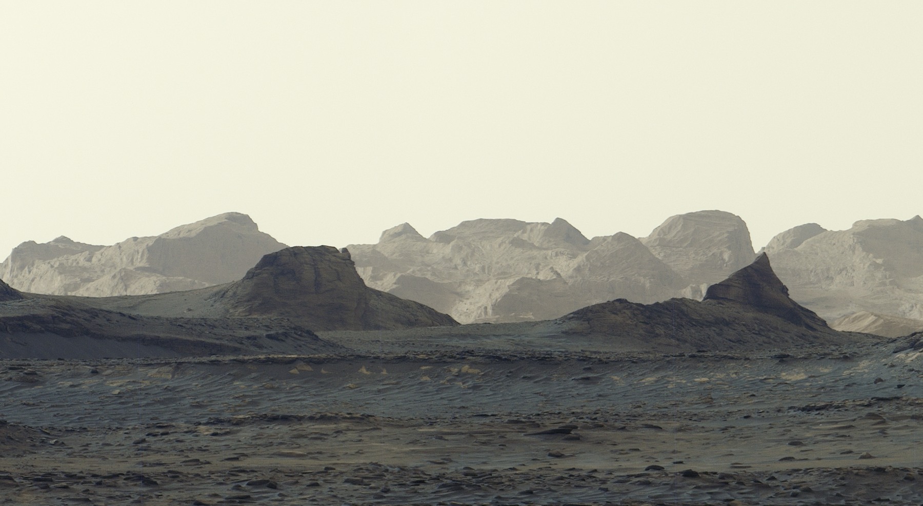

Mars is supposed to be the Red Planet. In Curiosity’s latest dawn panorama, the foreground takes on a striking blue cast—and the real puzzle is the band of cliffs behind it.
The rover photographed the scene at about 8:30 a.m. local Mars time on August 11, 2026. NASA released the view on October 6. Six Mastcam frames, stitched together on Earth without the usual white balancing, preserve an early-morning appearance that would otherwise be adjusted during processing. It is not evidence of blue vegetation or a newly discovered body of water.
Beyond that unusual light lie wind-carved formations called yardangs. Their colour, tilted layers and position on Mount Sharp have scientists asking whether this part of the mountain has a different origin from the terrain Curiosity has already explored.
The cliffs that do not quite fit
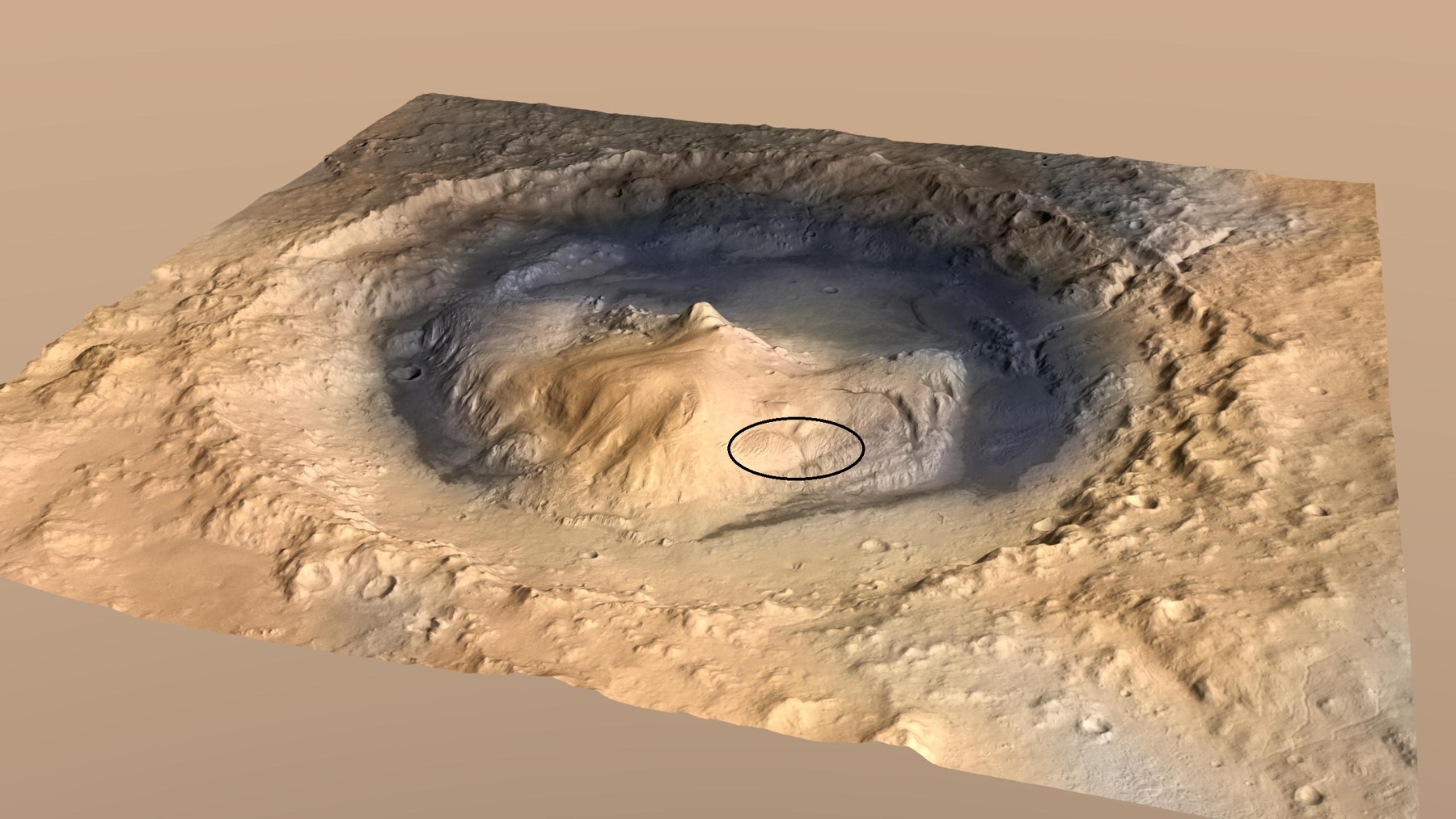
The yardang-bearing layer stretches roughly 10 miles, or 16 kilometres, across the northwestern part of Mount Sharp. That makes the image more than a close-up of an oddly shaped rock. It shows a substantial geological feature whose history could add a different chapter to the mountain’s record.
Mount Sharp rises about three miles, or five kilometres, inside Gale Crater. Curiosity has been climbing its lower slopes since 2014, studying layers that preserve evidence of environments billions of years old. Some record lakes and streams; others contain minerals associated with the landscape’s drying.
The distant cliffs stand out against that sequence. Ashwin Vasavada, the mission’s project scientist at NASA’s Jet Propulsion Laboratory, describes the layer as having the wrong colour and an unusual tilt, almost as though it had been attached to the mountain later. That mismatch is what makes it a scientific target rather than simply an impressive skyline.
Could an ancient eruption explain it?
One possibility is that volcanic ash settled here long ago. That could help explain why the layer looks different, but NASA presents it as an idea to investigate, not a settled identification. The panorama alone does not establish that an eruption created the deposit.
Wind has also been an important sculptor. Once material stopped accumulating on the mountain, erosion may have stripped some of it away, leaving the elongated ridges and crags now visible. Working out what was deposited, when it arrived and how it was later carved requires more than recognising a shape in a photograph.
Curiosity’s route gives researchers a way to connect those distant views with measurements made at ground level. Each layer the rover crosses can provide context for the next. A close inspection of the yardangs would therefore build on years of observations, not replace them with a single dramatic image.
Why the colours need context
Colour in a planetary image depends partly on illumination and processing. NASA says this panorama was deliberately produced without the usual white balancing, retaining the appearance of the early-morning scene. The six-frame mosaic is a processed scientific image, not an untouched snapshot from a phone.
That does not make it less real. It means viewers should understand what the processing preserves. The bluish foreground is not a claim that Mars has changed its overall colour, and the pale distant cliffs do not, by themselves, reveal their mineral composition. The mystery rests in geological relationships that the mission can test.
The gallery includes NASA’s cropped view of the cliffs, the wider dawn mosaic and an annotated artist’s concept locating the yardang layer. The illustration is a map-like guide to the terrain, not another photograph taken by Curiosity.
A slow climb toward a closer look
Curiosity recently passed one kilometre of elevation gained above the crater floor, the greatest climb yet achieved by a rover on Mars. That milestone is distinct from Mount Sharp’s full height: the rover has not climbed to the mountain’s summit.
The plan described by NASA is to spend much of the next year or so crossing layers enriched in sulfates and carbonates, minerals associated with ancient drying. Scientists hope to reach the base of the yardangs sometime in 2027, where the rover’s robotic arm could help collect closer-range information. That is a mission goal, not an arrival already completed.
For now, the photograph supplies both a remarkable view and a well-defined question. The surprising part is not that a camera can make Mars look blue at dawn. It is that, after years of climbing, a nearby layer can still look sufficiently out of place to challenge the story researchers are trying to reconstruct.