A buried North Sea crater had an asteroid secret. Tiny crystals helped settle it.
Seismic images, shocked minerals and modelling explain an ancient impact—not a current asteroid or tsunami warning.
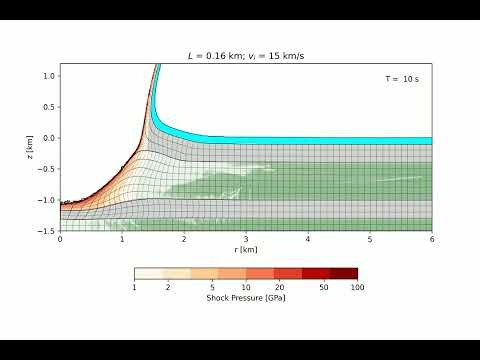
An asteroid roughly 160 metres wide struck the ancient North Sea, leaving a crater that is now buried beneath the seabed. For years, scientists argued about whether Silverpit really was an impact scar. Tiny shocked minerals helped turn that argument into a much stronger case.
A study published in Nature Communications on September 20, 2025, combined seismic imaging, rock samples from an oil well and numerical modelling. The authors concluded that the Silverpit structure was formed by a high-speed impact roughly 43 to 46 million years ago.
This is a geological discovery explained from an existing study—not a newly detected asteroid, a current tsunami alert or an impact that happened this week. The event is ancient; the evidence used to reconstruct it is what makes the story compelling.
A crater hidden under another landscape
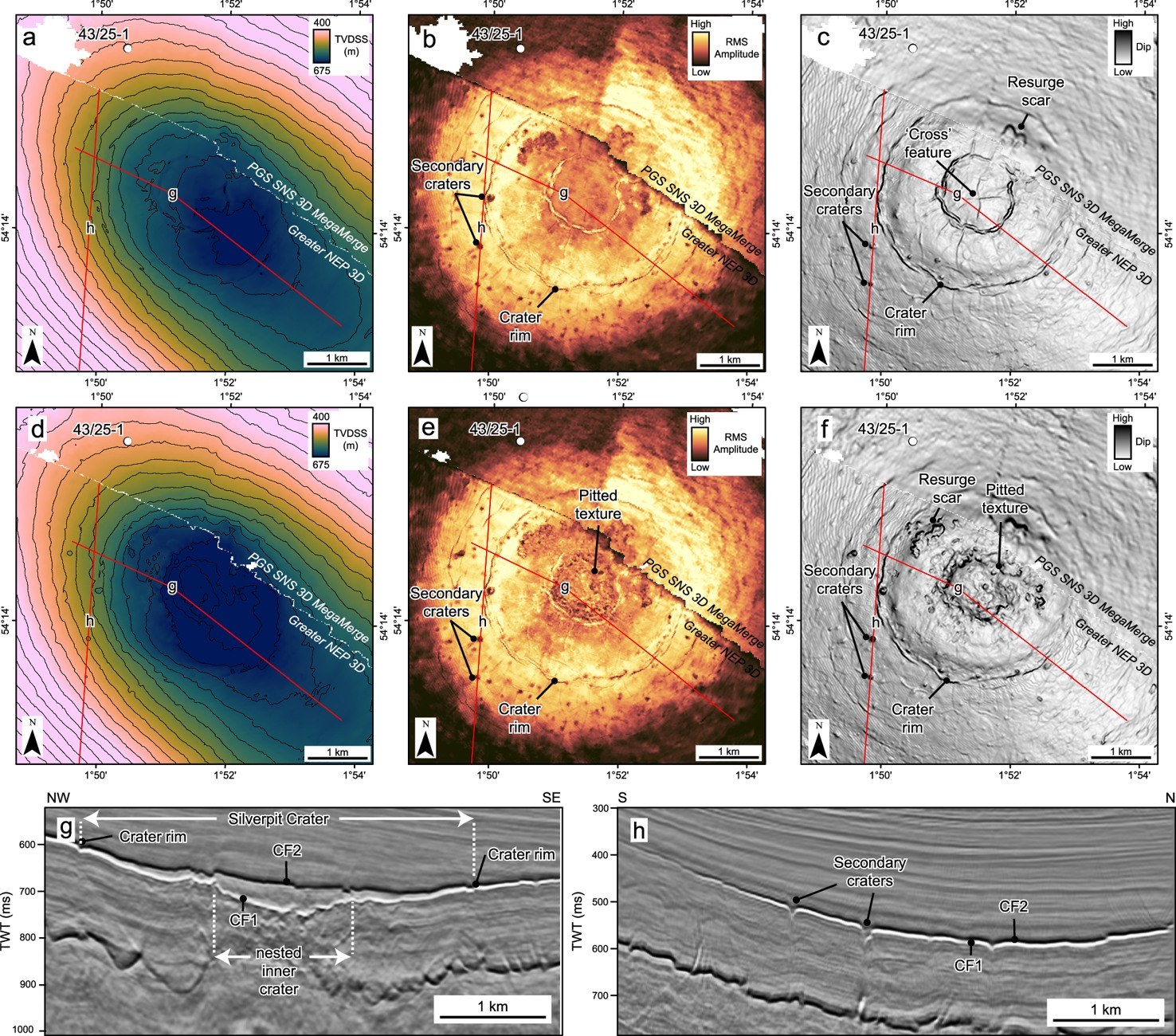
Silverpit lies in the southern North Sea, about 80 miles off the Yorkshire coast. Its central crater is roughly three kilometres across, with a wider system of faults extending far beyond the rim. Today, hundreds of metres of younger material cover it.
The structure was identified in 2002, but its origin was contested. A circular shape alone is not enough to prove an impact. Other proposed explanations included processes involving salt movement or collapse, and many geologists were unconvinced by the asteroid interpretation during a 2009 debate.
The later investigation, led by Uisdean Nicholson at Heriot-Watt University, revisited the question using higher-resolution seismic information and microscopic evidence. Seismic data reveal structures below the seabed by recording how sound waves travel through and reflect from different layers. They are not photographs of an exposed hole on the ocean floor.
The evidence small enough to miss
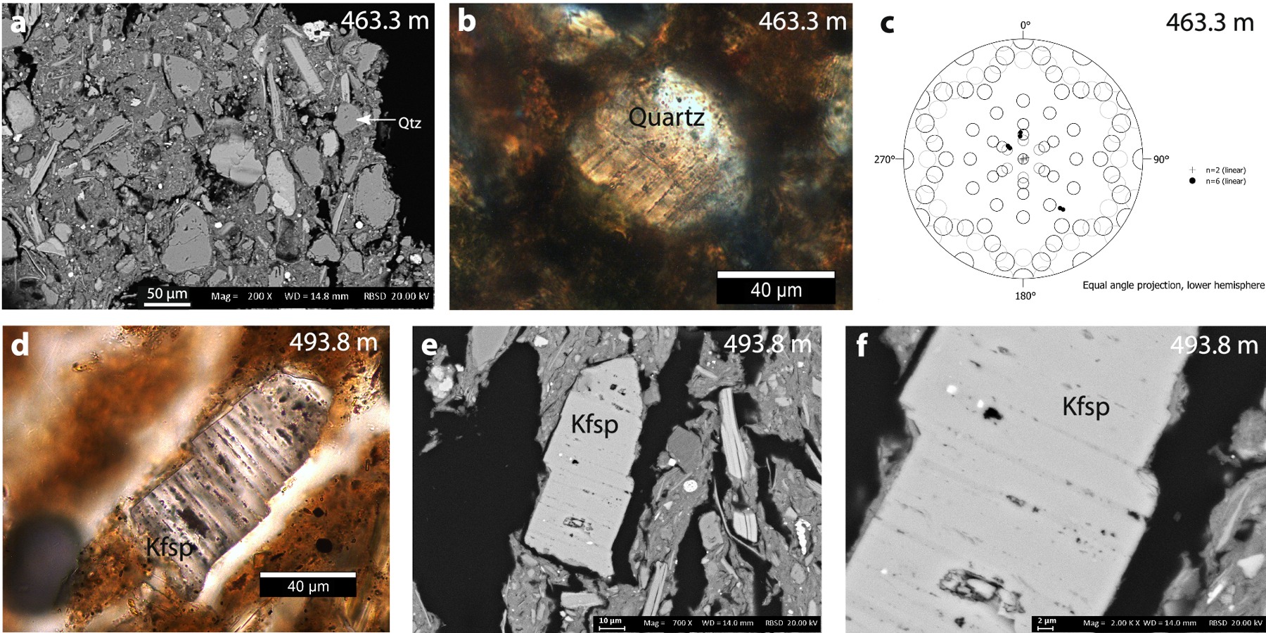
One particularly important clue came from cuttings recovered during oil-well drilling. Researchers identified shocked quartz and feldspar associated with the crater-floor sequence. Their microscopic internal features record extreme pressures rather than ordinary sediment accumulation.
In the university’s account, Nicholson describes finding the grains as a needle-in-a-haystack effort. The samples connect the large-scale shape in the seismic images with minerals that experienced the kind of shock expected in a hypervelocity impact.
This combination is more persuasive than any one dramatic image. A crater-like outline can invite several explanations; shock evidence and the structure’s deformation patterns help constrain which explanation fits. The study therefore draws on multiple lines of evidence rather than simply labelling a circular feature an asteroid crater.
Reconstructing the violence
The researchers modelled a rocky asteroid around 160 metres in diameter arriving at a low angle from the west. Their reconstruction describes an enormous curtain of rock and water, about 1.5 kilometres high, collapsing back toward the sea.
The university says the event would have generated a tsunami exceeding 100 metres in height. That is a reconstruction of conditions around an ancient impact, not a measured wave from a modern instrument. It is not a forecast for any present-day coast, and it should not be read as a map of how high water would reach everywhere around the North Sea.
The published simulation follows excavation of the crater, collapse and the return of water into the cavity. Numerical models help test whether an impact scenario can reproduce the geological structures. Their detailed appearance should not be mistaken for camera footage of the event.
Why a buried crater can be valuable
Earth is not an easy place to preserve impact scars. Erosion can wear them away, younger sediments can cover them, and tectonic activity can alter or destroy the record. Burial can make a feature difficult to find while helping protect parts of its structure.
Silverpit therefore offers a useful opportunity to examine what an impact does beneath a marine surface. Its central uplift, faults and surrounding deformation can be compared with the modelled sequence, while the well samples provide material evidence from within that buried record.
The gallery uses the study’s own seismic figure and mineral micrographs, not a stock picture of an asteroid approaching Earth. It also includes the university’s computer simulation as a click-to-play video, clearly identified as a simulation. The scientific figures are credited to the authors and linked to their open-access licence.
The date is part of the story
The work was published in 2025 and is presented here as a Facts explainer. Repeating it later does not make the research newly announced. That distinction is particularly important when words such as “asteroid” and “tsunami” can sound like immediate warnings.
What changed through the research was the explanation of an old structure, not the level of danger in today’s North Sea. A long-running geological argument was addressed by connecting a buried crater’s enormous outline with evidence inside mineral grains—features far too small to see from a ship above it.